-40%
APOLLO 12 16 and 17 LANDING SITE GEOLOGIC MAPS Special! SAVE ON ALL THREE!
$ 140.97
- Description
- Size Guide
Description
PRICE REDUCED!NOW WITH FREE SHIPPING!
Here is a set of three Apollo moon landing site maps for Apollo 12, 16, and 17. I am selling the same maps as individual items for 7, but for the whole set
you can save !
The pictures show each of the map sets, with three pictures for each.
Photos 1-3 - Apollo 12
Photos 4-6 - Apollo 16
Photos 7-9 - Apollo 17
Below are descriptions of each map set.
USGS
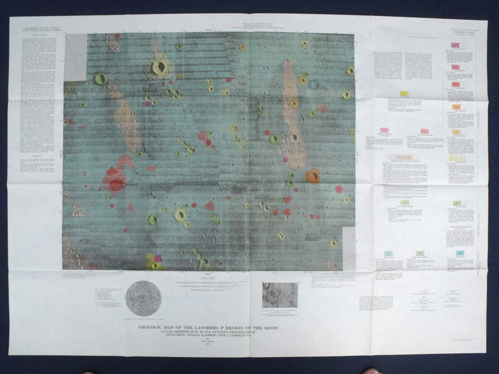
Map I-627
, “
Geologic Map of the Lansberg P Region of the Moon
” It also says “Lunar Orbiter Site III P-9, Oceanus Procellarum Including Apollo Landing Site 7
(Apollo 12)
”.
This is THE Apollo 12 landing site map, as well as the Surveyor 3 landing site. The two landing sites are indicated on the map!
This item consists of one large full-color map, an accompanying 4-page explanatory article, and the original manila sleeve. There is some very interesting history associated with this area of the moon, making this map among the most desirable of the lunar geologic maps.
Surveyor 3 was only the second soft landing on the moon ever achieved by a US spacecraft. Surveyor 3 initial touchdown occurred at 00:04:17 UT and final touchdown (it sort of bounced due to the landing rockets not cutting off correctly!) occurred at 00:04:53 UT on April 20, 1967 (19:04:53 April 19, EST) at 3.01 S, 336.66 E.
Two and half years later Apollo 12 landed near the Surveyor 3 site in Oceanus Procellarum near the rim of what had become known as Surveyor crater at 06:54:35 UT. Astronauts Conrad and Bean performed two surface EVA's, one on 19 November and one on 20 November, during which an Apollo lunar surface experiments package (ALSEP) was placed on the lunar surface, 34.4 kg of samples of the lunar terrain were acquired, various photographs were exposed by the astronauts during lunar surface activities,
AND parts were taken from the Surveyor 3 spacecraft for examination!
The map is at a scale of 1:100,000 and measures 28.5x41 inches. All three parts of this publication, the map, the article, and the sleeve, are in excellent condition. The map and article appear not to have been used at all. The map shows both the Surveyor 3 and Apollo 12 landing sites clearly marked. This was published in 1971. These are very rare.
USGS
Map I-748
, “
Geologic Maps of the Descartes Region of the Moon, Apollo 16 Pre-Mission Maps.
” This publication consists of two large full-color maps and the original manila sleeve.
Both of the maps show the Apollo 16 landing site.
This is a great set. The first map is at a scale of 1:250,000 and measures 21x38 inches. The other is at a scale of 1:50,000 and measures 30x44 inches. Both maps and the accompanying original sleeve are in excellent condition, without tears of even a minor nature. They are unmarked and appear not to have been used at all. This was published in 1972.
One map is a wide area map, showing the geology of the region, and noting the Apollo 16 landing site. The other map is closer up, and also shows the landing site. I've shown these features in the photos.
This set is complete, which is rare to find these days. Usually one or other map is missing, or the sleeve. This map never had an article with it. The set is complete as-is.
USGS
Map I-800
, “
Geologic Maps of the Taurus-Littrow Region of the Moon, Apollo 17 Pre-Mission Maps.
” This publication consists of two large full-color maps and the original manila sleeve.
Both of the maps show the Apollo 17 landing site.
This is a great set, and from a purely aesthetic standpoint these are the most attractive of all these maps. The first map is at a scale of 1:250,000 and measures 34x46 inches. The other is at a scale of 1:50,000 and measures 26x46 inches. Each map and the accompanying original sleeve are in excellent condition, without tears of even a minor nature. They are unmarked and appear not to have been used at all. The edge of the sleeve has slight folding that I only mention for completeness, as it would hardly qualify as damage or wear. This was published in 1972. These original maps will probably be highly sought after when we return to the moon, as there will likely be a resurgence of interest in the Apollo missions.
One map is a wide area map, showing the geology of the region, and noting the Apollo 17 landing site. The other map is closer up, and also shows the landing site. I've shown the two maps in the photos.
This set never had an article with it. It is complete as-is, which is rare to find these days.
This is a great opportunity to get these scarce maps together at a bargain price. Won't last through the year.
Expert packing assured. Buyer pays .00 for discounted Flat Rate Priority Mail shipping in box.
Visit my store,
Rockwiler Books and Minerals.
I will continue to add items to my store, so check back frequently.
®
ROCKWILER


